

4.6
Owner's of the Garmin GPS Receiver GPSMAP gave it a score of 4.6 out of 5. Here's how the scores stacked up:
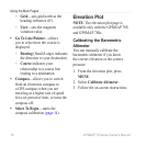
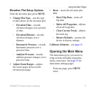

24 GPSMAP 78 Series Owner’s Manual
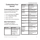
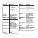
Customizing Your Device
Data Field Description
Depth The depth of the water.
Requires a connection
to a NMEA 0183
depth-capable device
to acquire data
(page 27).
**Descent
- Average
The average vertical
distance of descent.
**Descent
- Maximum
The maximum descent
rate in feet/meter per
minute.
**Descent - Total The total elevation
distance descended.
Distance to Dest. The distance to your
nal destination.
Distance to Next The remaining
distance to the next
waypoint on the route.
Elevation The altitude of your
current location above
or below sea level.
**Elevation
- Maximum
The highest elevation
reached.
**Elevation
- Minimum
The lowest elevation
reached.
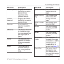
Data Field Description
ETA at Destination The estimated time of
day you will reach your
nal destination.
ETA at Next The estimated time of
day you will reach the
next waypoint on the
route.
Glide Ratio The ratio of horizontal
distance traveled to
the change in vertical
distance.
Glide Ratio To
Dest.
The glide ratio required
to descend from
your current position
and elevation to the
destination elevation.
GPS Signal
Strength
The strength of the
GPS signal.
Heading The direction you are
moving.
**Heart Rate
(heart rate monitor
required)
Your heart rate in beats
per minute (bpm).


Find Your Products By Category
- Lawn and Garden
- Computer Equipment
- TV and Video
- Laundry Appliance
- Kitchen Appliance
- Car Audio and Video
- Automotive
- Photography
- Fitness & Sports
- Personal Care
- Communications
- Home Audio
- Portable Media
- Musical Instruments & Equipment
- Baby
- Household Appliance
- Cell Phone
- Marine Equipment
- Outdoor Cooking
- Power Tools
- Video Game
Please Login
